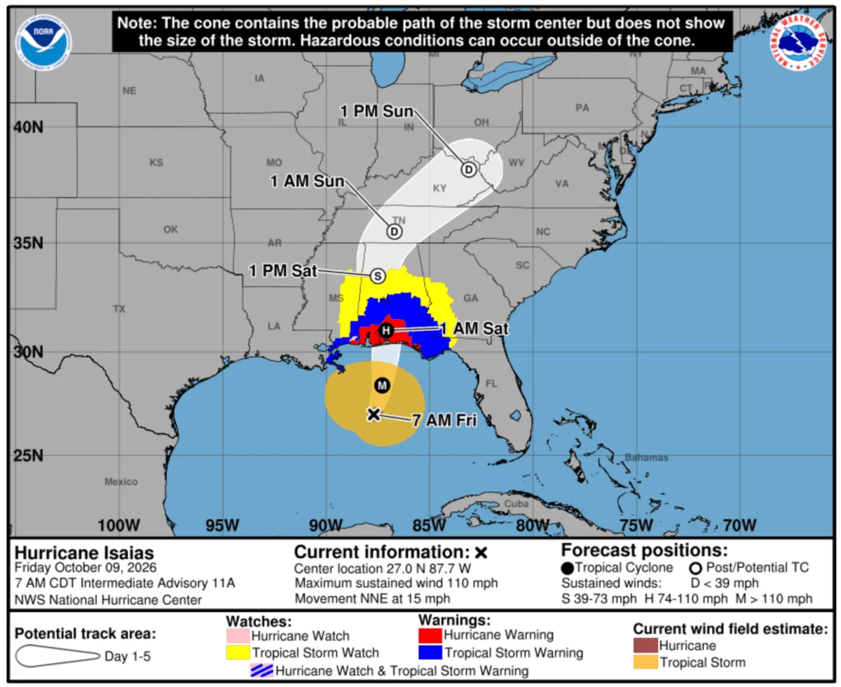
The 2026 Atlantic hurricane season has reached a historic and unexpected inflection point. As the calendar pushes toward the end of the year, Hurricane Isaias—pronounced "issy-ay-ahs"—has emerged as a meteorological anomaly. While the storm briefly intensified into a dangerous Category 3 hurricane over the warm waters of the Gulf of Mexico, experts anticipate a rapid degradation in intensity as it approaches the Alabama coastline.
Despite the forecasted weakening, the storm represents a significant logistical hurdle for the Gulf Coast, testing regional infrastructure and supply chain resilience. As the first major storm to reach the U.S. in the 2026 season, Isaias serves as a stark reminder that even late-forming systems require rigorous preparation and swift, coordinated responses from the public and private sectors.
The Meteorological Anomaly: A Record-Breaking Timeline
Meteorologically, Hurricane Isaias is distinguished not by its peak intensity, but by its sheer timing. According to climate data and seasonal tracking, Isaias marks the latest-forming hurricane in the Atlantic basin’s recorded history. This unprecedented delay is attributed to the "Super El Niño" weather pattern currently influencing global climate conditions.
The presence of a Super El Niño typically creates vertical wind shear in the Atlantic, which often suppresses the development of tropical cyclones. Historical data supports this correlation; in the previous three instances of a Super El Niño (1982, 1997, and 2015), the Gulf of Mexico remained devoid of hurricane activity. The emergence of Isaias in late 2026 breaks this historical pattern, signaling a shift in climate behavior that has caught emergency planners and logistics experts off guard.
Chronology of the Event: From Gulf Genesis to Landfall
The development of Isaias followed a rapid trajectory. After organizing over the Gulf of Mexico, the system underwent a period of intensification, reaching Category 3 status late Thursday. However, environmental factors, including cooler shelf waters and increased shear, are expected to sap the storm’s strength as it approaches the coast.
- Thursday Night: The storm achieves Category 3 status, prompting immediate activations from regional emergency management agencies.
- Friday Morning: The U.S. Coast Guard elevates the Port of Mobile to "Port Condition ZULU," mandating a full cessation of vessel traffic and cargo operations.
- Friday Evening/Saturday Morning: Landfall is projected for the Mobile Bay area in Alabama. Current models suggest a downgrade to a Category 1 hurricane or a strong tropical storm by the time the eye crosses the shoreline.
- Post-Landfall: Unlike previous, more destructive storms that stalled over the coast, Isaias is expected to maintain a steady, relatively rapid pace as it travels inland, limiting the duration of exposure for affected areas.
Supply Chain and Infrastructure Implications
For the logistics sector, the primary concern is not a catastrophic, multi-day weather event, but rather the targeted disruption of key transit corridors and port operations. Everstream’s chief science officer, Mark Russo, noted in a recent briefing that while Isaias will not rival the sheer destructive force of 2024’s Hurricane Helene or Hurricane Milton, it remains a "force to be reckoned with."
Critical Transportation Corridors
The storm’s projected path poses a threat to major interstate arteries. The I-10 corridor—specifically the stretch between Slidell, Louisiana, and the Florida Panhandle—faces potential flooding and closures. Similarly, I-65 near Mobile, Alabama, is currently being monitored for high-water impacts. These routes are essential for regional distribution, and any localized closure could result in significant "last-mile" delays for freight moving through the Southeast.
Port Operations and Maritime Traffic
The Port of Mobile is the epicenter of the disruption. Following the implementation of Port Condition ZULU, all vessel and terminal operations at Alabama Port Authority public berths have been suspended. The suspension is indefinite, pending post-storm damage assessments and the clearance of navigation channels. While cargo airports in the region currently remain operational, the ripple effects of a port closure often extend to inland logistics, forcing shippers to reroute cargo and adjust delivery schedules for perishable and time-sensitive goods.
Data Analysis: The Rainfall and Wind Factor
Everstream’s technical projections suggest that the total rainfall associated with Isaias will range between 3 and 7 inches. While significant, this is notably lower than the double-digit, multi-day drenchings often associated with slow-moving hurricanes. This reduced rainfall volume is a critical factor in determining the longevity of the supply chain disruption; because the storm is expected to move inland with relative speed, the window for massive, widespread flooding is compressed.
Wind speeds, storm surge, and power outage potential are currently classified as "moderate." While these risks are manageable, the unpredictability of storm surges in the low-lying areas of the Gulf Coast necessitates a cautious approach for businesses operating near the waterfront.
Official Responses and Strategic Mobilization
The mobilization of the American Logistics Aid Network (ALAN) underscores the severity with which the professional community is treating this late-season event. Kathy Fulton, ALAN’s Executive Director, has confirmed that the organization has entered a state of active mobilization.
"Isaias is expected to make landfall as a Category 2 hurricane—with massive rainfall, a potentially life-threatening storm surge, and winds as high as 110 miles per hour," Fulton stated. While model projections fluctuate, ALAN is operating under a worst-case scenario framework to ensure that relief supplies and logistics support are positioned to move the moment the storm passes.
Proactive Measures
ALAN’s response strategy includes:
- Prepositioning: Working with non-profit partners to stage essential goods and relief equipment near the impact zone.
- Rapid Assessment: Utilizing their specialized web portal to provide real-time updates on road closures, fuel availability, and power status, which is vital for commercial carriers.
- Cross-Sector Coordination: Acting as a bridge between the private sector and government entities to ensure that logistics professionals can assist in the recovery without hindering emergency responders.
Conclusion: Lessons in Modern Resilience
Hurricane Isaias serves as a definitive case study in the importance of constant vigilance. In a world where climate patterns like the "Super El Niño" can upend historical precedents, supply chain managers can no longer rely solely on historical averages to forecast risk.
The storm’s impact on the Gulf Coast will be defined by its ability to cause localized, yet high-impact, disruptions. With the Port of Mobile shuttered and critical interstate highways under threat of closure, the immediate future for regional logistics will be defined by the quality of communication and the speed of recovery operations. As the storm makes its final approach, the focus of the industry shifts from prediction to mitigation, relying on the robust, collaborative networks established by organizations like ALAN and the steadfast protocols of the U.S. Coast Guard.
The lesson of 2026 is clear: the hurricane season is not truly over until the final system has dissipated. By maintaining a posture of readiness, the logistics industry continues to demonstrate its ability to navigate the complexities of an increasingly volatile climate, ensuring that even in the face of record-breaking events, the flow of essential goods remains as resilient as possible.
About the Author